Summitville Mine
The Summitville Mine is an open pit site is found 25 miles
south of Del Norte, Colorado with an elevation of 11,500 feet above sea level
in southwestern Colorado. The mine site is located south of Wightman Fork,
about two miles east of the Continental Divide. The town of Summitville is just
to the north of the mine site on the other side of Wightman Fork (EPA) . The region is usually subject to severe winters with substantial snowfall that gather on steep slopes. Snow may usually remain on the ground until late spring or early summer. It provides water in sizes sufficient to keep streams flowing year-round, and the snow acts as a continual source of water entering the soil.

Gold and silver mining started at Summitville around 1870.
Large scale, open-pit mining started at the site in 1984. The mine operator was
Summitville Consolidated Mining Corp., Inc. They used cyanide heap leaching to
extract metals from the ore. In this process, the ore mined from the mountain
was crushed and placed onto the clay and synthetic-lined heap leach pad. Sodium
cyanide solutions were then applied to leach out gold and silver.
Almost immediately after its construction in 1986, there was
a leak detected in the heap leach pad. Summitville Consolidated Mining Corp abandoned
the site and announced that they were filing for bankruptcy in December 1992 (SUMMITVILLE MINE DISASTER). The EPA immediately presumed responsibility of the site as an act of emergency
response. On May 31, 1994 Summitville was put on the National Priorities List
of Superfund sites (EPA).

Copper, cadmium, manganese, zinc, lead, nickel, aluminum,
and iron have contaminated the surface water, groundwater and the soil.

In 1997, according to the Agency for Toxic Substances and
Disease Registry a public health assessment led to the classification of the
Summitville site as having no apparent public health hazard. However,
ecological impacts from site contaminants have been significant (THE SUMMITVILLE MINE AND ITS DOWNSTREAM EFFECTS). The Alamosa
River system below the site cannot currently support aquatic life. Studies show
that that there are negative effects to agriculture and livestock from regular
use of Alamosa River water.
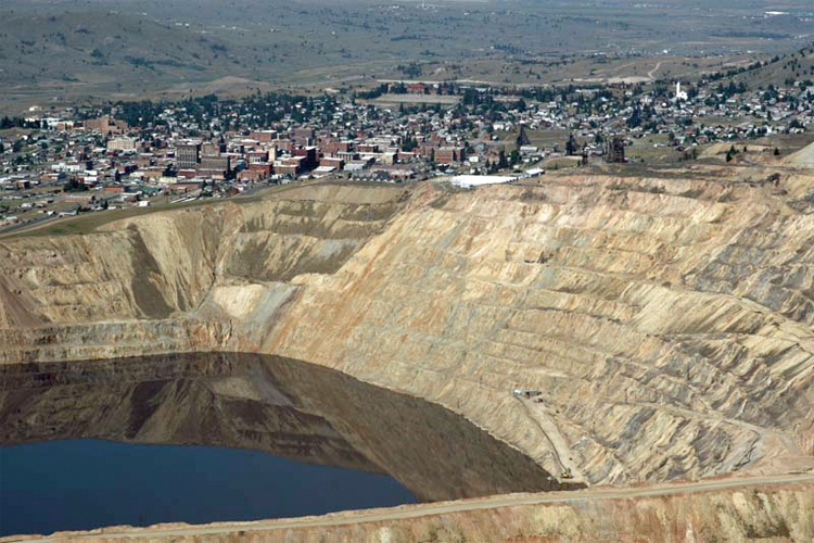
Berkeley Pit Mine
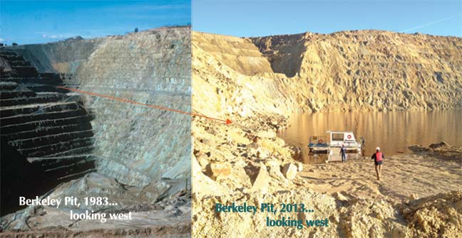
The Berkeley Pit was a former open pit copper mine located
in Butte, Montana, United States. It is a mile long by half a mile wide with a depth
of about 1,780 feet. It is filled to about 900 feet with water that is heavily
acidic. It has a 2.5 pH level and as a
result, the pit is overloaded with heavy metals and dangerous chemicals that
leach from the rock, including copper, arsenic, cadmium, zinc, and sulfuric
acid.
Approximately 320 million tons of ore and over 700 million
tons of waste rock were mined from the Butte Hill (Pitwatch).
As NASA states, "The mine took advantage of the existing
subterranean drainage and pump network to lower groundwater until 1982, when a
new owner suspended operations. After the pumps were turned off, water from the
surrounding rock basin began seeping into the pit. By the time an astronaut on
the International Space Station took this picture on August 2, 2006, water in
the pit was more than 275 meters (900 feet) deep." The acidity of the
liquid in the pit is so great that it is eating away at the rock and spreading
the acidic water around to surrounding surface water, groundwater, and soil.
Ultimately, about 1,000,000,000 tons of material was mined from the Berkeley
Pit. The acidity is so great, that in 1995, a flock of geese landed in the Berkeley
pit water, and all 342 geese died. After closer inspection by scientists, it
was revealed that the insides of the geese were lined with burns and festering
sores from exposure to high concentrations of copper, cadmium, and arsenic,
obviously linking the pit to the death of the geese.
To clean up the pit, a treatment plant has started construction
to treat the water in the pit and the tailings pond. The treatment plant should
be done and will be ready to treat the water and remove the toxins and acidity
of the water in 2018.
Both of these mines are on the federal EPA Superfund site list.
According to the EPA, "A Superfund site is an uncontrolled or abandoned
place where hazardous waste is located, possibly affecting local ecosystems or
people." The EPA helps analyze and protect the areas that have been
identified as Superfund sites and help to resolve the issues that the problem
presents to the environment. The Summitville mine is on the National Priorities
List, and as of now, the EPA has listed their work as a success, with current
human exposures at the site under control and contaminated ground water
migration is under control.
Work Cited
EPA. Superfund Process. Digital image. San Jacinto River Waste Community Involvement. EPA, 31 July 2014. Web. 12 Mar. 2015.
EPA. "Superfund Sites Where You Live." EPA. Environmental Protection Agency, 19 Feb. 2014. Web. 10 Mar. 2015.
Mining-technology.com. Open Pit Mine Planning. Digital image. Marston - Mining Engineers and Consultants. Mining-technology.com, 2015. Web. 12 Mar. 2015.
NASA. Berkeley Pit Mine. Digital image. Image of the Day Gallery. NASA, 23 Mar. 2008. Web. 12 Mar. 2015.
Plumlee, Geoffrey S. "THE SUMMITVILLE MINE AND ITS DOWNSTREAM EFFECTS." Ate THE SUMMITVILLE MINE AND ITS DOWNSTREAM EFFECTS. Usgs, 01 Jan. 1995. Web. 11 Mar. 2015.
Williams, Mark. Aerial View of Summitville Mine. Digital image. Landscapes and Water. University of Colorado Boulder, 1995. Web. 12 Mar. 2015.
William, Mar. "Toxic Waste Cleanup." Landscapes and Water (GEOG 1011): Summitville Mine Disaster. Mark Williams, 1 Jan. 1995. Web. 11 Mar. 2015.